Finding Wild Horses in Colorado
Return to Finding Wild Horses here for tips on visiting the range and to find herds in other areas
There are only 4 wild horse herds remaining in Colorado:
• Little Book Cliffs near Grand Junction
• Sand Wash Basin near the town Craig
• Piceance East Douglas between the towns of Rangley and Meeker
• Spring Creek Basin north of the town of Cortez, between Dove Creek and Naturita
• Little Book Cliffs near Grand Junction
• Sand Wash Basin near the town Craig
• Piceance East Douglas between the towns of Rangley and Meeker
• Spring Creek Basin north of the town of Cortez, between Dove Creek and Naturita
Little Book Cliffs Herd Management Area
Size: 36,113 acres
Number of wild horses the BLM deems appropriate for the herd area is 90-150
Size: 36,113 acres
Number of wild horses the BLM deems appropriate for the herd area is 90-150

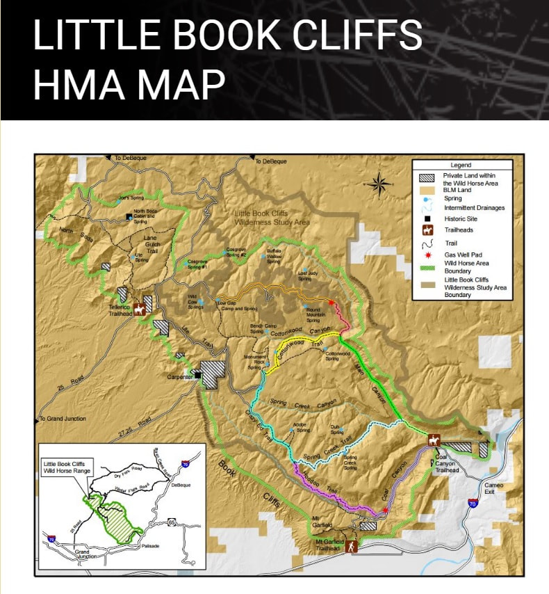
The Little Book Cliffs herd area is east of Grand Junction, CO, north of Interstate 70. There are a couple ways to get to the herd area including by 4WD or by hiking and all routes require high-clearance, four-wheel-drive vehicles.
The map to the left is directly from the BLM website: www.blm.gov/programs/wild-horse-and-burro/herd-management/herd-management-areas/colorado/little-book
I recommend printing it out and taking it with you.
A good access point, and the one closest to Grand Junction, is Coal Canyon Road to the Coal Canyon Trailhead, which begins at Cameo exit 46 from I-70 about 15 miles east of Grand Junction. Coal Canyon Road is closed from Dec. 1 to May 30 to protect foaling areas. From the BLM Map, it appears you can stay on the gravel road for quite a distance and it stays within the herd area - watch for signs stating you are entering or leaving the herd area. Other signs to watch for are recently used horse paths and fresh piles of manure along the road. This area is at the bottom of the cliffs.
Indian Park is a good place to view the horses and is accessible from the Winter Flats and Dry Fork roads, which begin near De Beque about 30 miles east of Grand Junction on Interstate 70. This is the route I took when I went out and it is gorgeous with canyons, hoodoos, and all sorts of gorgeous rock formations....and that's before you get to the herd area! Plan for a whole day with this route. Take exit 62 off Interstate 70 and turn north. Go approx. 4 miles on Roan Creek Rd then turn left onto S Dry Fork Rd (Rd 200). Stay on this road and when it splits stay to the left. You'll pass a ranch early on. Keep heading west and south to find the herd area. You'll cross cattle guards along the way.
Another option out of De Beque is to take Roan Creek a shorter distance to 2nd St, turn left, and make a right on V 2/10 Road. Stay left at the first two forks and continue heading west. There are many forks in the road along the way; keep watching for signs of horses, check each road as best you can but keep making your way west and south, not north.
These last two options take you up on top of the cliffs and along ridgelines at certain points. Some areas are quite rugged.
Piceance East Douglas Herd Management Area
Size: 190,130 acres
Number of wild horses the BLM deems appropriate for the herd area is 135 - 235
Size: 190,130 acres
Number of wild horses the BLM deems appropriate for the herd area is 135 - 235

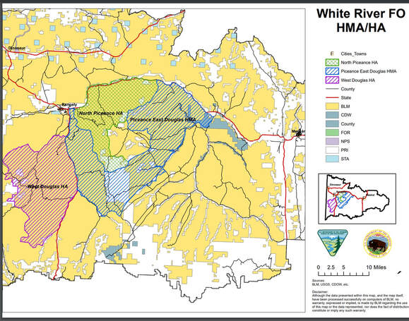
The Piceance East Douglas HMA is south and east of Rangley, CO, east of Hwy 139 and south of Hwy 64, southwest of Meeker. I have not yet visited this herd area so I have no photos to share with you.
The map to the left is directly from the BLM's website: www.blm.gov/sites/blm.gov/files/co_pedhma_map.pdf Note there are three herd areas on the map including West Douglas HA and the North Piceance HA - both of these herd areas have been zeroed out by the BLM and there are no wild horses remaining. The Piceance East Douglas HMA is in blue on the map.
Using this map, compare it to your new Recreation and Off-Road map to determine where you need to go to see the wild horses in the area.

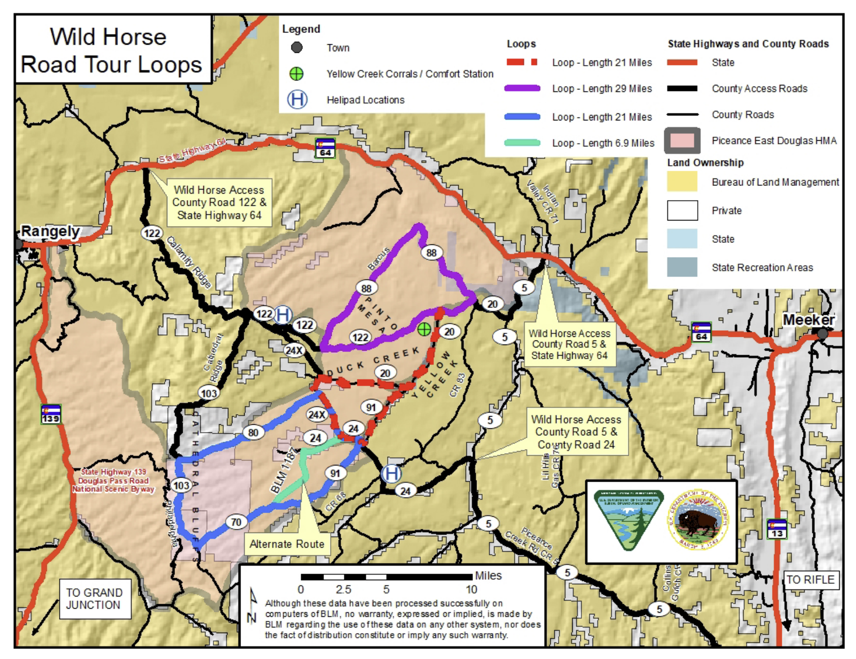
This 2nd map is provided by a local wild horse group and shows the roads you can take to get into the Piceance HMA
Sand Wash Basin Herd Management Area
Size: 157,730 acres
Number of wild horses the BLM deems appropriate for the herd area is 163-363
Size: 157,730 acres
Number of wild horses the BLM deems appropriate for the herd area is 163-363
The Sand Wash Basin herd area is 45 miles west of Craig, CO. A closer, much smaller, town is Maybell. From Craig take Hwy 40 W and at Maybell turn Right onto 318. Stay on 318 for 17.5 miles and turn Right onto County Rd 67. You'll see a sign for the Sand Wash Basin. 67 is a well graveled road and suitable for most vehicles; if you plan to take any side dirt roads or two-tracks, then a high clearance, 4WD will be needed. But you may be able to see wild horses from 67 at any point once turning off of 318.
Stay on Road 67 for at least 5.6 miles; at this point the road will fork. You can continue on 67 or turn Left onto Road 48 which is also a decent road suitable for any vehicle. There are a few dirt and two-track roads between 67 and 48 where you will find waterholes and perhaps wild horses. Ultimately the two roads form a loop with 67 going up to the top of the ridge and back down again. 67 turns into 126 which heads up to Lookout Mountain giving you a great view of the entire valley. At the top of Lookout Mountain you can continue straight to get onto 48 or turn left and stay on 126 to return to 48. It's hard to get lost in Sand Wash Basin if you just stay on the main gravel roads. Crossing over any cattle guards or through any gates will mean you are leaving the basin, so turn around.
Go slow to help keep the dust down and remember to stay on the roads at all time, never go off-road to get closer to wild horses. Most of the horses in the southern section of the basin were rounded up in the summer of 2021. If you have a high clearance, 4WD, you can make your way to the northern end of the basin to find wild horses too by staying on 67 instead of going up to Lookout Mountain.
Copper Pond when filled with water is a popular spot for the horses to water in the mornings and late afternoons; you will find Copper Pond on the right if you stay on 67 once entering the basin.
Spring Creek Basin Herd Management Area
Size: 21,932 acres
Number of wild horses the BLM deems appropriate for the herd area is 50-80
(this number has been increased from 35-65 to 50-80 since 2020)
Size: 21,932 acres
Number of wild horses the BLM deems appropriate for the herd area is 50-80
(this number has been increased from 35-65 to 50-80 since 2020)

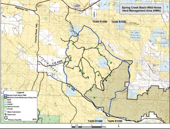
The map to the left is directly from the BLM's website: www.blm.gov/sites/blm.gov/files/whb_co_springcreek_map.pdf I recommend printing it out and taking it with you.
The Spring Creek Basin Herd Management Area is located off Hwy 141 between Dove Creek and Naturita, CO. From Hwy 141, turn south onto Road 19Q which will be a gravel road. From there travel 5.3 miles and take a left onto Road K20, a dirt road. You might see some horses right away and that is because you are now in the Disappointment Valley Sanctuary which is a sanctuary for Spring Creek Basin wild horses that were rounded up in 2009. This sanctuary is owned by The Serengeti Foundation. Thanks to the Foundation, these horses are able to continue living in the valley though separated from their wild bands by a fence line.
Travel just over 3 miles on Road K20 and you will enter the herd management area after crossing over 1-2 cattle guards. You will see the faded Wild Horses sign on your left. This main road is suitable for most vehicles, though remember that it is soft dirt and should not be driven when wet. There are several side roads you can take, most of which dead end, that give you more views of the valley and chances to spot wild horses. I was able to see a few bands by staying on the main road.


